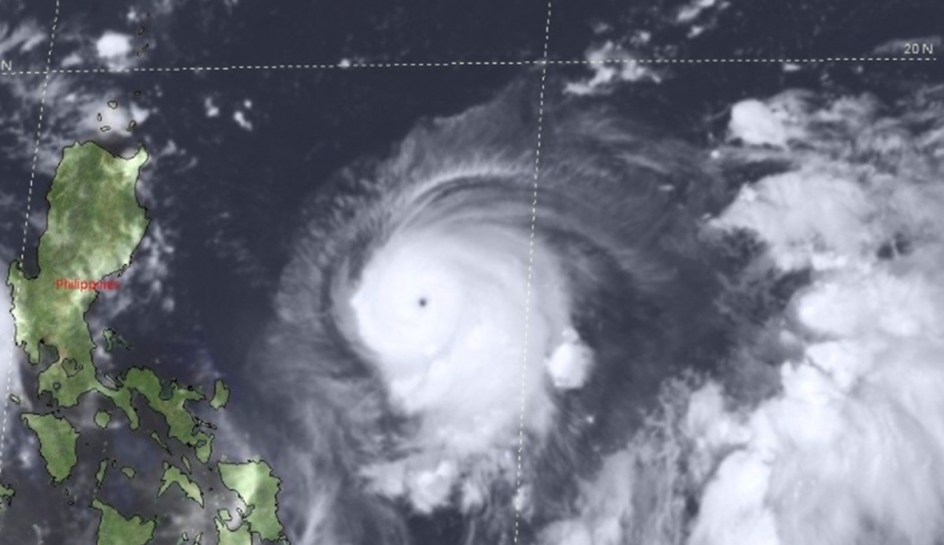
Tuguegarao City, Cagayan – DOST-Pagasa has raised Signal No.1 in Cagayan with parts of Isabela and Apayao on Thursday morning as typhoon ‘Kiko’ further intensifies.
Based on Pagasa’s 11am bulletin, ‘Kiko’ was last spotted approximately 670 kilometers east of Baler, Aurora with sustained winds of up to 195 kilometers per hour and gusts reaching 240 kph.
The state weather bureau has raised Tropical Cyclone Wind Signal (TCWS) No.1 over Cagayan province along with the Babuyan Islands, the towns of Sta. Maria, Divilacan, Palanan, Maconacon, San Pablo in Isabela, as well as Apayao province’s towns of Luna, Flora, Sta. Marcela, and Pudtol.
The typhoon is now moving westward with a speed of 20kph, and is reported to continue packing intensity with a forecast peak strength between 185 to 205kph on Thursday night to Friday morning.
Pagasa added Cagayan province, Babuyan Islands and Northern Isabela are to expect heavy to intense with occasional torrential rains on starting on Friday night.
Moderate to heavy rains are also expected over the rest of Isabela and the island province of Batanes.
The weather experts said typhoon ‘Kiko’ has a possibility of making landfall in Cagayan basing on its southward shift in its recent track forecast.
Pagasa said in a statement, “As such, the public is advised to continue monitoring for possible changes in the track forecast in the succeeding bulletins.”
The storm is expected to move west northwestward within the next 12 hours before turning northwestward until Saturday, plowing close to northeastern of the southern and western parts of Batanes province.
The state weather bureau added that Kiko will be 285kms east of Tuguegarao City on Friday morning, over the coastal waters of Basco, Batanes by Saturday morning and 360kms north northwest of Itbayat, Batanes by Sunday morning.
The typhoon is expected to exit PAR by Monday morning with its tail 660kms north of Itbayat, Batanes by then. TNF


