Tropical Storm (TS) Karding is expected to strengthen into a typhoon and make landfall in Isabela and Aurora on Sunday afternoon, while the southwest monsoon continues to bring rain to the MIMROPA region.
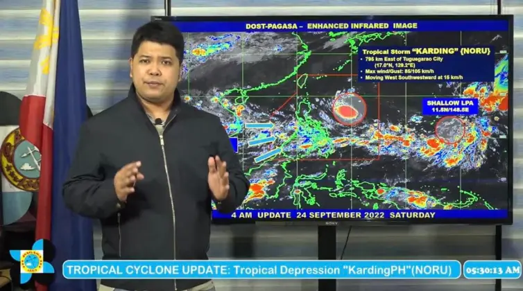
Weather forecaster Obet Badrina said Saturday morning that Karding was last located at 795 kilometers east of Tuguegarao City with maximum sustained winds of 85 kilometers per hour (kph) and gustiness of up to 105 kph. It is moving west-southwestward at 15 kph.
“Base sa ating latest na track, ito ay babaybay sa bahagi ng Northern Luzon patungo sa West Philippine Sea at bandang araw ng Lunes, ito ay nasa labas na ng Philippine Area of Responsibility (PAR),” he said.
Tropical Cyclone Wind Signal (TWCS) No. 1 was issued by PAGASA over Isabela, Nueva Viscaya, Quirino, the southern portion of mainland Cagayan, Kalinga, Mountain Province, Ifugao, Aurora, and the northern and eastern portions of Nueva Ecija.
Light to moderate rain will fall over Batanes, Cagayan, Isabela, and the northern portion of Aurora from Saturday evening to early Sunday morning.
PAGASA’s latest track and intensity forecast says that Signal No. 3 is most likely the highest TWCS that will be raised.
“Hindi natin inaalis ang posibilidad na magtaas tayo hanggang Signal No. 4 kapag umabot sa typhoon category itong bagyong Karding. Bago mag-landfall ay posibleng umabot ng typhoon category–kapag ang bagyo ay nasa karagatan pa, posible itong lumakas, nag-iipon pa ng lakas, pwedeng mag-intensify ang Karding bago tumama sa kalupaan,” he said.
The southwest monsoon or habagat, which is influenced by Karding, will bring rains to most of Southern Luzon, Manila, and the Visayas from Saturday evening to Sunday.
The moderate to rough seas at 1.5 to 3.5 meters will be observed over the seaboards of Northern Luzon. The rough to very rough seas at 2.8 to 4.5 meters will prevail over the eastern seaboards of Northern and Central Luzon due to Karding.
PAGASA may issue a gale warning advisory within the day, it added.


